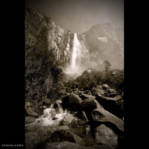
Tuesday, June 9, 2009

Magical Morning

Magical Morning

I got home late that night, put on a movie, Paul Blart, Mall Cop. It was pretty funny, so if I was lucky got maybe an hour of sleep, awakened by the barking dog to peek outside for some amazing pre-dawn colors. Jumped out of bed, and drove down the st to my nearest beach with free parking. I knew it was going to be a good one, so I just grabbed my over-sized back-pack (tamrac expedition 8x) from the night before (still had all my lens's & strobes) Got set-up for some beautiful colors, but then 10 minutes later the clouds over the horizon started glowing pink and the tide was just right screaming shoot me! anyways went back to sleep & relaxed most of the day. It was one of the best sunrises I've ever waken up to!

Hope you enjoy! I know I did!

Buy my art at Imagekind!

Large

Happy Birthday Hector!!

Happy Birthday Hector!!

Today's Hectors Birthday!

I also re-worked the color HDR version, looks 100x better! maybe I'll post it in the future?

16 Things About SMGallery

LA, LA. .

Thursday, June 4, 2009

Iaysha

Iaysha

Shooting again with Hector in the studio, but I couldn't help but fire off one with the 50mm 1.4. It's one of my new favorite lens's

Sorry for not getting back to Yosemite photos, but if I don't edit these now they will sit in the archives & we wouldn't want that would we?

Make sure you check out Hectors 5 light set-up.. Looks like a shot from Tool-Time? =)

Large

Ethan the guitarist. .

Ethan the guitarist. .

I've never meet so many real people in one day. I had a blast walking around Long Beach with Hector. Hopefully we get a chance to go back soon & visit with our new friends!

Strobist Info:
1 SB24 in a shoot thru brolly camera left

I was parked at a 24 minute parking meter, so a 5 light set-up was out of the question. Plus the wind was starting to pick up.

June Gloom @ CDM

June Gloom @ CDM

Out with Hector
again... Going for a more natural look.. .

Buy my art at Imagekind!

Seems like I forgot about Yosemite, but I promise to get back to it asap!~

en.wikipedia.org/wiki/June_Gloom

Another Nadiah Shoot

Another Nadiah Shoot.. .

Strobist Info:

AB1600 In 60" Umbrella Above Model
AB1600 in 43" Umbrella Below Model
Clamshell Lighting
SB800 Camera Left for Rim
SB24 Camera Right for Rim
Nikon D300
Nikkor 50mm 1.4
Cybersyncs & Pocketwizards

I went shooting today with Hector aka BigboyDrums, and he's teaching me off camera lighting using up to 5 lights in trade for my landscape seminar. I was lucky enough to not only shoot on scene, but in his studio as well! Let me tell you his pp is nuts! I can't wait to get a Wacom Tablet!

Anyways, we posted the same photo, different pose, but he kicked me ass in the pp!
www.flickr.com/photos/bigboydrums/3580238337/

Yosemite

Bridalveil Fall

Bridalveil Fall

Elevation at trailhead: 4,000 feet (1,200 meters)
Elevation Gain: 200 feet (60 meters), more or less

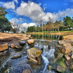
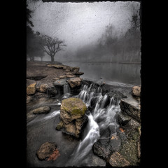
Why Hike to Bridalveil Fall? At 620 feet (189 meters), this cataract is short compared to Yosemite Falls, but we're still willing to bet you don't have anything like it in your neighborhood. It's famous for the mist that wafts off it when the breezes blow and which, according to the poetic, isolation-addled souls who get to name waterfalls, resembles a bridal veil.

Best Time to Visit: In the springtime, when the snowmelt is roaring over the falls and you'll need windshield wipers for your spectacles - sometimes from a quarter mile away.

Hiking Time: 15 - 30 minutes

Crowd Factor: As heavy as the waterflow, generally. Along with Lower Yosemite Falls, this is one place where virtually every tour bus is sure to stop, so crowds will appear in waves.

Difficulty: Easy; we rate it a 1 out of 10. There's some incline and the spray-soaked path can be slippery near the falls, but it's still a hike that almost anyone can do.

Parking: A large lot at the trailhead. It often fills up, but if you drive a few hundred meters into the valley, you'll find a trail to the falls running parallel to the road, and you can almost always find a parking spot somewhere along here, with the added bonus of having a view of El Capitan. We prefer this longer trail anyway. It crosses Bridalveil Creek and some pleasant meadows - and really, the more of Yosemite Valley you walk through, the happier you're going to be.

Nearest Restrooms: In the parking lot.

Nearest Snacks: Assuming that all the cooler-laden cars in the parking lot are out of bounds, your best bet is Yosemite Village, five miles east.

Getting There: From Yosemite Valley, take Highway 41, which heads towards Wawona and the south park exit. You'll reach the Bridalveil Falls parking lot very shortly after turning onto Highway 41. See the trail map for a clearer idea.

Beware of: slippery rocks. The mist that gives the falls their name makes footing treacherous as you approach the falls.

Best Views: They aren't always from the very end of the trail, which is near the base of the falls. During the spring runoff, there's so much mist whipping off the falls that the only people who'll go there are small children who've been ordered by their parents to risk their tiny, expendable lives to pose for pictures, or me. (next time I should have my water-housing or maybe some windshield wipers) =)

Just wanted to say thank you to Phil King who happens to work for Flickr. He picked my buddy Shawn & I up when we got lost after our 12 mile hike to the sequoia trees. We happen to miss our turn to the campgrounds & wound up 3 miles outside of Yosemite.

www.yosemitehikes.com/yosemite-valley/bridalveil-fall/bri...
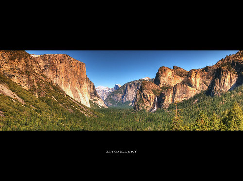
The Tunnel View

The Tunnel View

The Tunnel View is probably Yosemite's most famous vista. Lots of famous landmarks are visible here, including, from left to right, El Capitan, Clouds Rest, Half Dome, Sentinel Rock, Sentinel Dome, Bridalveil Fall, and a tree.

If you enter Yosemite Valley via Highway 41, this will be one of your first glimpses of Yosemite Valley; you'll see this immediately upon exiting the eponymous tunnel just uphill from the viewpoint. If you entered Yosemite Valley via another route, follow the signs to Bridalveil Fall (or Highway 41), but continue uphill past the falls to this spot.

View On Black

Buy my art at Imagekind!

Thursday, May 7, 2009

Piru Creek

Piru Creek

Piru Creek

Few of the hundreds of thousands of people that have driven up Interstate 5's Castaic grade, thirty minutes north of downtown Los Angeles, are aware of the stunning gorges that are found along Piru Creek upstream and downstream of Pyramid Reservoir.

Located just south of the intersection of the San Andreas and Garlock fault zones, the creek winds its way through land twisted and torn by the combined effects of these major faults, the related San Gabriel fault, the Pine Mountain fault, and several other smaller faults. The result is a stunning streamscape with towering cliffs, tilted strata, deep gorges, and remarkable views.

Add water and the reach between Pyramid dam and Lake Piru becomes one of the most unique, isolated, and scenic one-day, road accessible, whitewater runs in the Western U.S. It is considered a "must do" classic by many expert whitewater kayakers.

Water is the key. Water years with average,or above average, precipitation will usually produce some boatable days in February and March. But since the dam is just upstream, the release from Pyramid is the primary source of the water at the put-in. Sometimes it is necessary for boaters to make their way downstream on marginally boatable flows until side creeks add sufficient water.

You don't have to be a geologist to appreciate the unique terrain of Piru Creek -- you just need to be able to gawk at the rocks, cliffs and gorges in the 2500 ft. deep canyon and say, "Wow!" Want a "before you paddle" preview? Here's a Google Earth image of Piru Creek and Google Earth KMZ file of Piru Creek that shows much of the creek from Frenchman's Flat (on the left) to Lake Piru. Zooming in, here's a image of the "Falls Gorge" section, pictured on the right. For more info see Google Earth.

read more here
or
en.wikipedia.org/wiki/Piru_Creek

My buddy Jeff wanted to go fishing, so I packed my camera gear of course and tested out some new techniques my contacts have been asking me about.. stacking filters, testing the full capacity of the lee filter foundation. so I started with the HoyaND400, but I was blowing out my sky, so I tried my 3stop reversed gnd, and it didn't look so natural. The Lee .0.9 (3-stops) GND works wonders and is much stronger than cokin if you're rugged like me, its worth the extra cash.. =)

Wednesday, February 11, 2009

Grass Valley Lake Vertorama


Grass Valley Lake is a small private lake owned by the members of the Lake Arrowhead Country Club. This doesn't mean that you can't enjoy it too. The lake is a short 10 minute drive from the Lake Arrowhead Village.

Winter Wonderland


Winter Wonderland
Originally uploaded by smgallery


Welcome to Lake Arrowhead Country Club...

For this is a place where bald eagles glide over fairways shouldered by towering sugar pines and incense cedars. Where you can stop and listen to the cool winds in the lofty trees, the lapping of clear water, the superb silence of serenity.

The club of choice for discerning golfers for over 40 years, LACC is a fully appointed facility with a magnificent tennis venue and beautifully situated swimming pool and aquatic deck.

Less than two hours from Los Angeles, San Diego or Palm Springs; Lake Arrowhead Country Club is a mile high oasis of pleasure for avid golfers, enthusiastic tennis players and busy families looking for a relaxing escape from the heat and humdrum of life "down-below". To visit once is to want to stay forever.

Monday, February 9, 2009

Tewinkle Park Vertorama


Tewinkle Park Vertorama
Originally uploaded by smgallery
My 1st vertorama I posted on Flickr.com/smgallery

TeWinkle Park
970 Arlington Dr., Costa Mesa, CA, 92626
(714) 548-4165
Features a lake and waterfall, tennis and volleyball courts, ball fields, playground, picnic tables and more.

Tuesday, February 3, 2009

Balboa Park


. . .
Originally uploaded by smgallery
WELCOME to BALBOA PARK
Welcome to Balboa Park - the nation's largest urban cultural park. Home to 15 major museums, renowned performing arts venues, beautiful gardens and the San Diego Zoo, the Park has an ever-changing calendar of museum exhibitions, plays, musicals, concerts, and classes—all in the beautiful and timeless setting of this must-see San Diego attraction.

ADMISSIONS and the PASSPORT TO BALBOA PARK
The admission prices vary by institution. Memberships are also available for purchase from the museums and performing arts organizations, offering an opportunity for visitors to support these San Diego cultural treasures on an annual basis. Admittance to the Park grounds is free. The Botanical Building, outdoor gardens and some additional attractions are also offered free of charge.

Passport to Balboa Park, San Diego's best cultural value, offers visitors the chance to experience 13 museums in the Park, with savings of more than 50% and the convenience of a one-time purchase. The Passport is valid for seven consecutive days, and includes one admission to each of the 13 attractions. The Zoo/Passport Combo includes the Passport to Balboa Park plus one-day deluxe admission at the San Diego Zoo, all for one low price.

www.balboapark.org/

Monday, February 2, 2009

The Jewel


La Jolla
Originally uploaded by smgallery
La Jolla in Spanish means "The Jewel". It is the Jewel of America's finest city, San Diego. La Jolla is located 15 minutes from downtown San Diego. It has wonderful beaches, cultural activities and fine restaurants. La Jolla is an exquisite combination of a southern European resort atmosphere and Southern California fun. While La Jolla is known to be one of the most affluent communities in the United States, it has a down to earth feel due to the beautiful natural scenery and the helpfulness of its residents. Moreover, in addition to fine restaurants, beautiful beaches, hotels and art galleries, La Jolla is home to renowned institutions, such as the Scripps Institution of Oceanography and the Stephen Birch Aquarium & Museum. This is in addition to the University of California, San Diego. Furthermore, La Jolla is home to many Bio-Tech and software companies. In short, La Jolla is a great place to live in, visit, or do business.

Saturday, January 31, 2009

Minnesota State Fair


Minnesota State Fair
Originally uploaded by smgallery
This is from my summer excursion. I worked a total of 6 fairs, so this shots from the Minnesota State Fair.

The fairs I traveled:

San Diego Fair
Costa Mesa Fair
Minnesota State Fair
Oklahoma State Fair
Tulsa State Fair
Arabian Horse Show, Tulsa, OK

www.mnstatefair.org/

Wednesday, January 28, 2009

Abalone Cove


Abalone Cove
Originally uploaded by smgallery
I've had a few people ask me about which filters I use, so here it goes.
-Lee Filters Holder System Foundation Kit which does not include the Lens Adaptor Ring. Together its about $150 & no you do not see the filter when shooting even @ 10mm
-4"x6" Lee .75 ND Grad Hard
-4"x6" Cokin Z-Pro Graduated Neutral Density filter: Tobacco 125S

Prints For Sale

Location: 5500 Palos Verdes Drive
Rancho Palos Verdes, CA 90275

Hours: Monday-Friday 12-4 p.m.; weekends and holidays 9 a.m.-4 p.m.

Parking: $5 in a big dirt lot

Phone: (310) 377- 0360

Beach Information
Special Comments: Looking off of the cliffs the view is amazing. You can enjoy scuba diving and fishing at this beach. This is an exquisite spot to have lunch on one of the many picnic tables. It's a steep trail down to a long sandy shoreline. There is no food in the area, so pack a lunch. Restrooms are located at the trailhead and down below on the beach. Fishing is not allowed at Abalone Cove Shoreline Park. Facilities include diving, picnic tables, lifeguards and tidepools.

Restrooms: Located at the trailhead and on the beach.

www.rockcitynews.com/pages/california/labeaches/abaloneco...

Tuesday, January 27, 2009

DreamScape


Dream Homes
Originally uploaded by smgallery
Corona del Mar (Spanish for the Crown of the Sea) is a community as beautiful as its name. Nestled on the foot of the San Joaquin Hills and fronting the Pacific Ocean, Corona del Mar ranges along a bluff at the south end of Newport Beach and includes some of Orange County's most prestigious residential areas.


Offering a unique selection of shopping, restaurants, services and retail fashions, our seaside village is conveniently located just 50 miles south of Los Angeles International Airport, 4 miles west of John Wayne Airport and 70 miles north of San Diego.
Click here for a location map
www.mapquest.com/maps/map.adp?country=US&addtohistory...


The Chamber serves as a strategic business resource dedicated to developing the local business environment and enhancing the quality of life in Corona del Mar. Dedicated to providing unique and customized promotional benefits and networking opportunities to meet the expanding needs of our member organization...Click here for more info
www.cdmchamber.com/about/default.asp

www.cdmchamber.com/default.asp

Santa Ana River Jetties


Santa Ana River Jetties
Originally uploaded by smgallery
The Santa Ana River Jetties is actually one large area…but it has several distinct sub-areas. Most people consider the zone that starts directly south of the Brookhurst Outflow and runs to a couple hundred feet south of the Santa Ana River Mouth to be the actual River Jetties surf spot. Personally, because the influence of the river mouth is so great, I feel that you should include all of the coast down to about Prospect St. (which is a couple of hundred yards north of the 56th street jetty).

The northern part of the SNA River Jetties is one of the most visible surf spots in Newport. You can see it as you drive over the PCH bridges that separate Huntington Beach from Newport. It is also sort of a weird no-mans land between the two cities. It is actually managed by the county and partially by the state beach. It has a separate lifeguard agency, from either Newport Guards or HB State Beach, and even the single tower doesn’t have a number on it…just the letter “R”, which I like to think stands for River Tower. What is really nice about this set-up is that they don’t blackball this area…it stays surfable all day even when the other beaches have banned hard surfboards.

The River Jetties has three rock jetties that were put in place by the Army Corp of Engineers to stabilize the sand flow at the mouth of the Santa Ana River. Two of the jetties sit on the north side of the river and the other, which is a little shorter, rests on the south side. It is the combination of the river, these jetties, and the various sand transport currents that helps to build a part of the most consistent sand bar in North Orange County. The bar generally starts up around the Brookhurst jetties and then ends down past the river proper.

While most of the sand stays around the river it does occasionally make its way down the beach…and after good rains or big swells you can have some excellent sand bars down in “official” Newport territory.

Overall the waves in this area are pretty good most of the time and can be excellent on the right swell mix. The sandbar helps keep it breaking through all but the most extreme high tides. The waves are steep, hollow, and can get pretty closed out on bigger S and WNW swells. Combo swells work best at this spot, like most of the breaks in the region, so expect it to get good when you have the magic swell combo mix of S and WNW energy and offshore winds.

This spot actually does pretty well on windswell too. The shallower sandbar helps the shorter-period swell set up further off the beach, and in a more energetic fashion that a deeper bar would.

One big drawback about the River Jetties, and Brookhurst, is the water quality. The combination of pollutants from the storm drains and the junk that comes down the Santa Ana river keeps water-quality on the marginal side most of the year. If there is any sort of rainfall it knocks the water quality right into the hazardous range.

Spot details:
Best swell direction: SE-SW (160-210+) and W-NW (260-290)
Best Wind: N-NE-E, light-moderate Santa Ana winds are the best.
Sea Floor: Sand…really shallow sand, and few rocks near the jetties
Best Season: Summer, Fall, and Winter can all be equally great. Fall is the most consistent.

Crowds: Most of the time not too bad. But it can get super crowded. You see heavy crowds when it is the only sandbar working or on weekends, particularly in the summer.

Posted by Adam Wright at 11:27 pm
socalforecast.blogspot.com/2008/03/surf-break-maps-santa-...

Labels: newport beach, orange county, santa ana river jetties, southern california, surf break maps

Sunday, January 25, 2009

Down with the LBC


Down with the LBC
Originally uploaded by smgallery
As you might of heard I finally got the chance to meet John aka Extra Medium
www.flickr.com/photos/johnmueller/
He had a very unique client shoot yesterday which took us to Shoreline Park in Long Beach. I photographed behind the scenes of John and a yoga instructor in various poses on the beach and park, and then we went to town with the amazing weather!

Saturday, January 24, 2009

SMGallery


SMGallery
Originally uploaded by smgallery
Self Portrait of me last night at the Huntington Beach Pier, CA

Friday, January 23, 2009

Final Lap


Final Lap
Originally uploaded by smgallery
Long Beach Grand Prix, Long Beach, CA
www.gplb.com/index.php

Wednesday, January 21, 2009

Good Morning!


Good morning!
Originally uploaded by smgallery
Surf Break Maps: Santa Ana River Jetties, Newport Beach, Orange County, California
The Santa Ana River Jetties is actually one large area…but it has several distinct sub-areas. Most people consider the zone that starts directly south of the Brookhurst Outflow and runs to a couple hundred feet south of the Santa Ana River Mouth to be the actual River Jetties surf spot. Personally, because the influence of the river mouth is so great, I feel that you should include all of the coast down to about Prospect St. (which is a couple of hundred yards north of the 56th street jetty).

The northern part of the SNA River Jetties is one of the most visible surf spots in Newport. You can see it as you drive over the PCH bridges that separate Huntington Beach from Newport. It is also sort of a weird no-mans land between the two cities. It is actually managed by the county and partially by the state beach. It has a separate lifeguard agency, from either Newport Guards or HB State Beach, and even the single tower doesn’t have a number on it…just the letter “R”, which I like to think stands for River Tower. What is really nice about this set-up is that they don’t blackball this area…it stays surfable all day even when the other beaches have banned hard surfboards.

socalforecast.blogspot.com/2008/03/surf-break-maps-santa-...

www.surfline.com/surf-report/santa-ana-river-jetties-sout...

Tuesday, January 20, 2009

Home Sweet Home


Home Sweet Home
Originally uploaded by smgallery
Santa Ana River Jetties is the most consistent spot in Newport. If Huntington looks flat, go check River Jetties because there's almost always something to ride. River Jetties is, however, extremely varied in shape and depends on the contour of the sandbars. Lefts tend to be fast and predominant during south swells and can turn hollow on a light offshore wind. Westerly winds easily blow out the spot. In winter, the break is far peakier. Steep peaks are found on the right tide, but if you don't surf the spot regularly, the chances of a great day are slim.

Because River Jetties is a fast shortboard wave, you tend to get aggressive crowds. It's one of the few breaks in the city where you don't have hoards of beginners swarming the peaks. If you can lay down a solid turn, you're welcome out there.
-- Blair Mathieson

www.surfline.com/surf-report/santa-ana-river-jetties-sout...

Monday, January 19, 2009

Bolsa Chica


Bolsa Chica
Originally uploaded by smgallery
The Bolsa Chica Conservancy is a non-profit, non-political organization whose mission is to advocate the restoration and preservation of the Bolsa Chica Wetlands through public outreach, participation, education and leadership. We are a coalition of responsible community leaders from science, business, education, and government.

In summary: We restore. We educate. We advocate.

The Bolsa Chica Ecological Reserve extends along the east side of Pacific Coast Highway in the city of Huntington Beach from Warner Avenue to Seapoint Avenue. It is open to the public daily from sunrise to sunset.

The Bolsa Chica Wetlands Interpretive Center is located at 3842 Warner Avenue, which is at the southeast corner of Warner Avenue and Pacific Coast Highway. A second parking lot is located on the east side of PCH, 1 mile south of Warner.


Interpretive Center Hours:

Tuesday-Friday 10 am - 4 pm
Saturday 9 am - noon
Sunday 12:30 pm - 3:30 pm

http://www.bolsachica.org/About/mission.html

Sunday, January 18, 2009

Follow Me


Follow Me
Originally uploaded by smgallery
A neighborhood in Newport Beach, this seaside village is located on the foot of the San Joaquin Hills and fronting the Pacific Ocean.
Restaurants and trendy shops are popular hangouts in Corona del Mar. On East Coast Highway, you'll find plenty of dog walkers and moms with strollers - getting their exercise while window shopping at the many studios, design shops, antique stores and galleries such as McKibben Studios a gallery of fine surf and island art.

The beaches and parks in Corona del Mar will also keep you active. You can swim, surf or go diving at Corona del Mar State Beach, or snorkel at Crystal Cove State Park.

http://www.orangecounty.net/cities/CoronaDelMar.html

Saturday, January 17, 2009

The Helmsman


The Helmsman
Originally uploaded by smgallery
The Helmsman

1931-1950. Carl Romanelli. Burton W. Chance Park, Marina del Rey.
Text from the plaque: For many years, this statue stood in front of and was a trademark for the world renowned Helms bakery on Venice boulevard in Los Angeles. On October 6, 1971, it was generously donated to the Marina by the Helms family. In 1975, through the generosity of the Marina's Yacht clubs it was provided with a new helm.

"The Helmsman is an approximately 10-foot tall cast concrete figure in staunch repose with both hands clenched on a wooden helm. His posture is tight, his body hunched over, and his expression determined. Although formerly the symbol of the unfaltering delivery service of the Helms Bakery, The Helmsman fits perfectly in this maritime environment."

Friday, January 16, 2009

Aliso Beach


Aliso Beach
Originally uploaded by smgallery
Aliso Beach is an easy going family beach with picnic tables, firepits and even playground equipment for the kids. Located in Laguna Beach, it is fantastic for families seeking room to roam.

http://www.beachcalifornia.com/alisobch.html

Thursday, January 15, 2009

Last One Standing


Last One Standing
Originally uploaded by smgallery
I'm just trying to mix it up a little and get away from my landscapes for a second. Hopefully you like it! ~Mr Moore

Tewinkle Park #2


Tewinkle Park #2
Originally uploaded by smgallery
A park in Costa Mesa, Ca. I try to stay close to the house now that gas prices are going back up. Plus I'm not selling any prints. =(

Wednesday, January 14, 2009

Newport Beach


Newport Beach
Originally uploaded by smgallery
I love to shoot here because it's only 10 minutes from my house plus free parking!

Monday, January 12, 2009

sunrise reflections


sunrise reflections
Originally uploaded by smgallery
sunrise reflections from marina del rey

Saturday, January 10, 2009

Let's go fishing


Let's go fishing
Originally uploaded by smgallery
Sunrise this morning from Lake Irvine

I didn't have any fishing gear with me this morning, just my camera. Luckily the lady was nice enough to give me a wristband for 15 minutes, otherwise it's 22$ to enter.

Thanks again for giving me that 15 minutes!! Trust me I'll be back to do some fishing!

View On Black

irvinelake.net/irv/vt.php?t=3

Tewinkle Park


Tewinkle Park
Originally uploaded by smgallery
www.orangecounty.net/html/park-costamesa.html

Testing my new Daryl Benson Reverse GND

There has been alot of trash washing up on our beaches, so this one called for a little more cloning than I like. I also removed some boats and the wedge from the background.